
10 Natural Wonders travel in Australia | discover the top picks
Natural Wonders
Australia is not just about the splendid Sydney Opera House or the majestic sandy beaches. While man-made architectural wonders and beaches can be found in many other countries and regions, what makes Australia unique and special is its amazing and spectacular natural wonders. Mother Nature has gifted Australia with breathtaking scenic landscapes and incredible biodiversity, shaped by our planet’s geological and ecological processes over millions of years.
- Great Barrier Reef
- Uluru-Kata Tjuta National Park
- Daintree Rainforest
- Kakadu National Park
- Ningaloo Reef
- Blue Mountains
- Fraser Island (K’gari)
- Kings Canyon
- Cradle Mountain
- Lord Howe Island
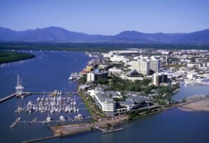
Great Barrier Reef, Queensland mainland, Australia
Location: Off the east coast of the Queensland mainland, Australia
— 20,000 years ago, this area wasn’t even underwater. It was covered with eucalyptus and paperbark forests. It was also home to animals commonly found on the Australian plains. Aboriginal people likely lived here, too, hunting wildlife in areas that are now deep underwater.
Then, 10,000 years ago, at the end of the last Ice Age, ice at the poles melted, and sea levels rose all around the world, flooding this low-lying coast. Stories of the Great Flood are still passed down in Aboriginal culture today. As the sea rose, corals began to grow on the rocky fringes of the continental shelf, creating the Great Barrier Reef we see today.
These shallow tropical waters are clear and warm—perfect conditions for coral to thrive. Sheltered behind this long strip of reef, a lagoon was born—an area of protected water larger than all of Great Britain. With it came a new coastline of shallow, sandy waters. The rising sea cut off areas of high ground, creating the 600 islands that dot the lagoon.
Some are little more than rocks, while others are substantial mountains covered in woodland. The Great Barrier Reef is so large that it can be seen from space—quite an achievement considering the size of the creatures that built it.
Uluru-Kata Tjuta National Park, Lasseter Hwy, Uluru NT 0872, Australia
Location: Lasseter Hwy, Uluru NT 0872, Australia
Uluru Kata Tjuta National Park—no trip to Central Australia is complete without a visit to Uluru Kata Tjuta National Park. The park covers 1,325 square kilometers and contains a 348-meter-high rock. Uluru is very important to the native people of the area, the Anangu. It is partly a cultural history and traditional belief site. The Anangu people believe they must not climb Uluru, but they don’t stop visitors from going up. However, they prefer visitors to walk around the base of the rock. In the park, there is a cultural center.
The cultural center offers information and activities for visitors. Here, visitors can find guides who can take them around Uluru and tell them about the history of the rock. Walks around Uluru take about three and a half hours. Visitors must bring water with them and should drink one liter of water for every hour they walk. They also shouldn’t walk during the hottest time of the day. There are walking paths in the park, and it’s a good idea for visitors to stay on the paths to avoid getting lost or disturbing the park’s ecosystem.
Visitors should also wear long trousers and protective footwear in case they come across a snake. The hours of operation for this park are 5 a. m. to 9 p. m. for summer, while its winter schedule is 6:30-7:30 p. m. Camping in the park is not allowed, though just outside its edges you can find many hotels. A day at Uluru Kata Tjuta National Park would surely be your memorable experience of the great Australian Outback.
Daintree Rainforest, 2333 Cape Tribulation Rd, Cape Tribulation QLD 4873, Australia
Location: 2333 Cape Tribulation Rd, Cape Tribulation QLD 4873, Australia
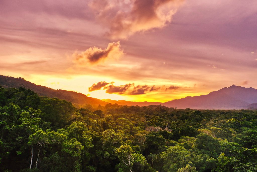
The Daintree Rainforest is Australia’s largest area of continuous rainforest. It covers an area of 1,200 square kilometers, extends to the Coral Sea, and is connected to the marvelous Great Barrier Reef. The rainforest is at least 135 million years old and might even be as old as 180 million years. The Daintree has witnessed the dinosaur era, experienced the last Ice Age, and endured other major events. The rainforest still harbors about 12% of the world’s primitive flowering plant species. It is a splendid region featuring glowing.
bioluminescent mosses, fungi, and even worms. One can observe bright bursts of light created by fireflies drifting through the leaves, especially after rain. It is home to some of the world’s tallest tropical trees, like the magnificent Bull Kauri, a conifer species that can grow up to 50 meters tall and 2.7 meters in diameter.
The Daintree Rainforest also encompasses other massive trees, such as emergent trees that gain maximum sunlight and attract pollinators. Their height gives them an evolutionary advantage. The rainforest supports 65% of all of Australia’s bat and butterfly species, 28% of frogs, 40% of birds, 34% of mammals, and 65% of ferns in the country. There are also around 12,000 types of insects and over 200 species of land snails found in the Daintree Rainforest.
Within the region, there is a river known as the Daintree River, which was discovered in 1873 and named after English-born Australian geologist and photographer Richard Daintree. The rainforest is home to a diverse array of species, including rare and endangered animals such as the giant southern cassowary, Bennett’s tree kangaroo, and the white-lipped tree frog—the world’s largest frog.
Unique species like Boyd’s forest dragon, the spotted-tail quoll, and the bright blue Ulysses butterfly can only be found in the Daintree Rainforest and nowhere else on Earth. The incredible natural beauty and immense wildlife diversity of the Daintree Rainforest make it one of the most extraordinary places on Earth.
Kakadu National Park, Kakadu Hwy, Jabiru NT 0886, Australia
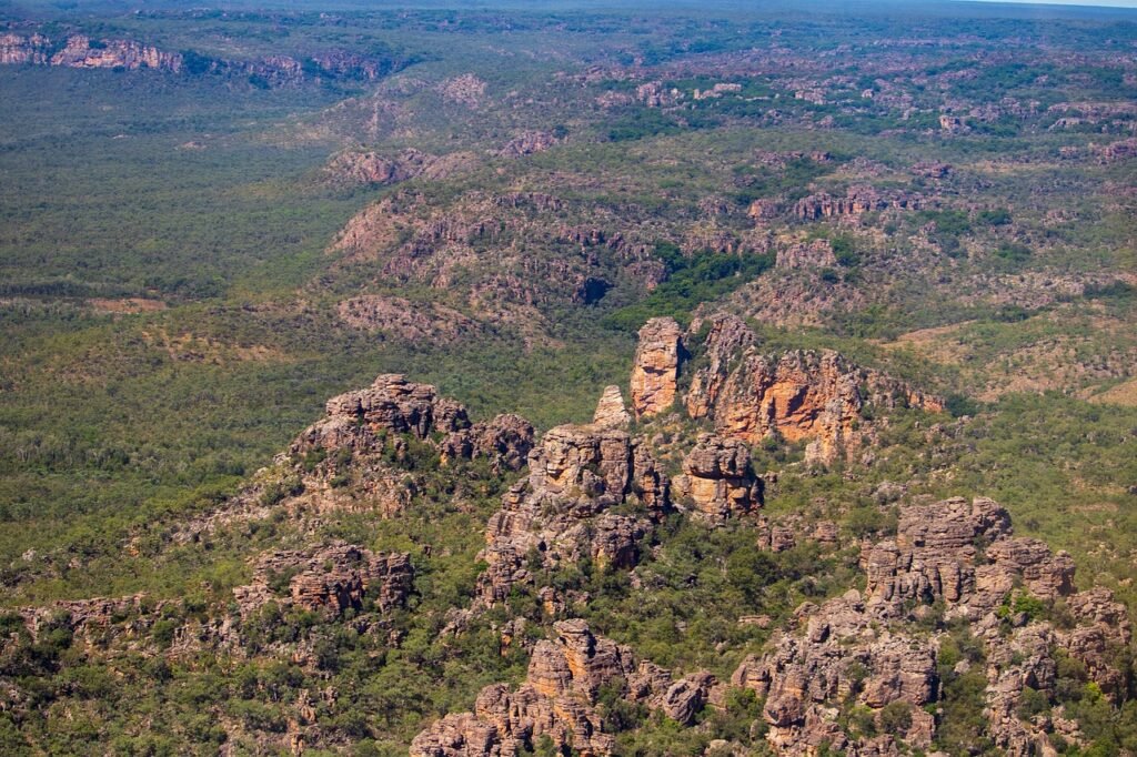
Location: Kakadu Hwy, Jabiru NT 0886, Australia
Kakadu lies 150 miles east of Darwin, in a region Australians fondly call “The Top End.” While Canberra might be the seat of the nation’s power, Kakadu is one of those few places where you’ll discover the country’s soul. World Heritage-listed Kakadu is a geological, biological, and cultural wonderland. It’s more than just a national park—it’s a national treasure.
The Bininj and Mungguy people have been caring for this country for over 50,000 years and today are happy to share parts of their Country, knowledge, and Dreaming with you. A three-hour drive from Darwin, Kakadu is open year-round, but most visitors come during the Dry Season, from May to October, when most of the park’s roads are open.
Just because this is the Outback, don’t think you have to rough it. There are comfortable hotels and campsites, as well as visitor centers where you can stock up on supplies, fuel, and information. You’ll need to set aside a few days to fully explore Kakadu, and once there, the best way to experience the park is by off-road vehicle and on foot.
The park has around 25 marked trails, from short walks to multi-day hikes. The walk to Jim Jim Falls is only half a mile, but it’s a walk you’ll never forget. Clamber through a lost world of hidden canyons, past waters that mirror the sky, before arriving at an ancient plunge pool surrounded by perfect beaches and 500-foot cliffs.
Six miles away is Twin Falls. Here, at the end of a forested gorge, is the sort of place many dream about but few will ever see. Another great place to cool off is Gunlom Falls. From the campground, hike to the top of the falls for views all the way to far-off Arnhem Land, then take your pick from a series of crystal-clear pools shaded by eucalypts.
Kakadu is dotted with thousands of art sites, with some ancient galleries featuring paintings dating back over 20,000 years. Created using local ochres, and sometimes even blood, these artworks provide insight into the lives of Aboriginal peoples throughout the centuries. Nourlangie Rock was the wet-season home to generations of Aboriginal people.
Here you’ll come face-to-face with Namarrgon, The Lightning Man, who, every wet season, splits open the clouds with his axe, bringing thunder and new life to the country below. A couple of hours’ drive to the north are the galleries of Ubirr. See paintings of the Rainbow Serpent, the wildlife of the wetlands below, and above, in impossibly high places, paintings said to be created by mimi spirits.
At the end of the day, climb up to the outlook and wait as Mother Nature paints her own masterpiece across the sky. Another great way to explore Kakadu is by boat. Take a cruise through the park’s richest wetlands, the Yellow Water Billabong. Drift across lotus-covered floodplains, past Jabiru and Magpie Geese, and say G’day to the park’s most famous residents—the salt- and freshwater crocodiles.
But to really appreciate the incredible scale and majesty of Kakadu, take to the air. A chartered flight will have you soaring over the East Alligator River, Dinosaur Valley, and the Magela Wetlands—places untouched by the hands of time. So, if you’re dreaming of adventure, don’t just dream—do it. Come and share the spirit of Kakadu. It’s been waiting here since the dawn of time, just for you.
Ningaloo Reef, Western Australia, Australia
Location: Western Australia, Australia
The Ningaloo Reef, a UNESCO World Heritage site. Ningaloo Reef is one of the five largest coral reefs in the world. It is home to over 500 species of fish, endangered whales, turtles, and sharks. The whale shark, the world’s biggest fish, is what draws people to Ningaloo Reef every year. As a marine researcher, being at this really special place is super exciting. We normally don’t come to places like this—it’s very difficult to get here. And of course, being able to jump in the water and look at some of the corals and fish species that we don’t see on the east coast is something I can’t wait to do.
Ningaloo Reef is Australia’s largest fringing reef—it’s directly fringing the coast here, unlike the Great Barrier Reef on the other side of Australia, which is further off the coast. So this is actually a bit of a marine hotspot, with biodiversity that you don’t find for thousands of kilometers. We’ve got minke whales, Bryde’s whales, blue whales, and, of course, humpback whales. There are also lots of small fish that live in this area that we don’t actually have on the other side.
Ningaloo also hosts one of the world’s most spectacular coral spawning events, clouding the reef with plumes of pink and red every year. It’s almost unbelievable that this special place is threatened by the oil and gas industry. Woodside has left a massive piece of industrial junk that has been reported to contain toxic fire retardant just 15 kilometers away from Ningaloo Reef. Fossil fuel giant Woodside is pushing ahead with the most climate-polluting project currently proposed in Australia. If it goes ahead, it would threaten the migration routes of whales, their feeding grounds, and sensitive marine areas like the Ningaloo Reef or the Scotts Reef further north.
This was magical—so many different corals, lots of colorful reef fishes, a little reef shark underneath. Oh, and before we got in, we saw a whale shark further out. It just makes you think—we really need to protect this beautiful space and ensure it’s not destroyed by a new fossil fuel project.
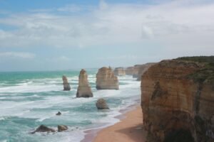
Blue Mountains, New South Wales, Australia
Location: New South Wales, Australia
The Blue Mountains—10,000 square kilometers of World Heritage National Park. It’s only a train ride away from Sydney, and when you get here, you don’t need a car to get around. Trolley Tours invite you to join us for a preview of some of the fabulous places you’ll see.
Katoomba is a derivative of the Aboriginal word “Kadumba,” meaning “Valley of the Waters.” Initially developed in the 1860s as a service town for the railway, it soon became a thriving tourist destination.
Katoomba has traditionally been a town of artists and performers, with festivals and events like Winter Magic showcasing everybody in action.
There are 29 trolley bus stops, and you can hop on and off all day. We’ll get you to all the great views and magical bushwalks. Next stop after Katoomba is the township of Leura. It’s a great opportunity to browse through the arts, crafts, and gift stores, and have a cup of coffee or a meal. Jump back onto the trolley bus and head to the Everglades Gardens.
In the 1930s, wealthy carpet manufacturer Henry Van de Velde and garden designer Paul Sorensen assembled a team of workers to create an extraordinary family retreat from the city. The design features sweeping lawns and European-style gardens set against a backdrop of native bushland.
Our route takes you through the natural wonders of this area. You can get up close to this ancient land, whose traditional owners are the Gundungurra and Darug people, who have lived here for over 20,000 years. Our World Heritage status was awarded in recognition of the outstanding value of the natural vegetation. Many species are only found in this area, and some of them are ancient, dating back to the age of the dinosaurs.
At 900 meters above sea level, the Three Sisters is one of the most recognizable formations in the world, towering above the majestic Jamison Valley.
All of this is easily accessed by riding the trolley bus. You don’t need a car to see the most amazing sites. We can drop you off at the Scenic Skyway, where you can take a journey across the valley 270 meters above ancient ravines and dazzling waterfalls. The views are breathtaking, and the cabin features the world’s first electro-sceni glass floor.
Scenic World started in 1945 when Harry Hammon took over the old coal mine railway and turned it into a passenger-carrying tourist attraction.
You can still head into the Jamison Valley on the steepest inclined railway in the world. When you’ve finished exploring the valley floor, take the 545-meter ride back to the top on the Scenic Cableway.
When you visit us in the mountains, don’t forget that we’re the only coach operator with a daily service from Katoomba to the famous Jenolan Caves.
We hope you’ve enjoyed this preview of the great places you can see by riding the trolley bus. So jump on the train to the Blue Mountains. When you exit the station, we’re just across the pedestrian crossing. Trolley Tours are carbon-neutral, so when you ride with us, you’ll be doing your bit to help the environment.
Fraser Island (K’gari), QLD, Australia
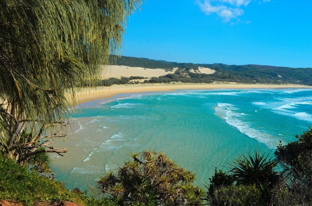
Location: QLD, Australia
Off the east coast of Australia’s mainland lies an extraordinary island wilderness, an enormous expanse of sand upon which the natural world has thrived. This is a land of towering rainforests, mighty dune fields, and crystal lakes—a sanctuary for wildlife, from Australia’s largest land predators to visitors from the deep. Once known as Fraser Island, today it goes by its traditional name:
Gari. In Australia’s Indigenous language, this means Paradise. Join us on a journey of discovery as we uncover the natural wonders of Gari, the largest sand island on Earth.
Gari lies east of the Australian mainland in a subtropical region known as the Fraser Coast. For more than 900,000 years, sand has been deposited here, conveyed by longshore ocean currents. Rocky headlands in the island’s north acted as giant barriers, collecting sand and gradually bringing form to the island. Wind action has continuously sculpted and resculpted the landscape. But rather than forming lifeless dune fields, something remarkable happened. Windborne nutrients deposited on the sand fed microscopic fungi, which, in turn, made nutrients available for plants.
First came colonizing grasses like spinifex, followed by shio and bankus. In time, entire forests emerged and expanded across the island. The first human inhabitants were Indigenous Australians known as the Butchulla people. Evidence of their occupation dates back more than 5,000 years. Gari’s interior holds many surprises.
Sitting high above the ocean, on top of sandy dunes, are freshwater lakes. There are more than 40 here. Lake McKenzie is a perched lake; its base has filled with organic material, creating a barrier that prevents rainwater from seeping out. The ancient sands on its shores are almost pure silica, washed clean of all their minerals. The water is so pure it cannot support wildlife. On its shores, however, small plants have adapted to the low-nutrient conditions. Sundews are tiny carnivorous plants. On their surface are sticky hairs that attract and trap passing insects. The plant digests and draws nutrients from its prey.
Eucalypt woodlands extend across much of the island. The understory is covered with brackens and grasses, along with evergreen species like foxtail sedge. Gari contains more than 30 species of lizards, with the lace monitor being its largest. When fully grown, they can reach lengths of 2 meters and weigh up to 14 kilograms. Like snakes, monitor lizards detect prey by collecting scent samples with their tongues. With voracious appetites, they will eat anything smaller than themselves. Their skin is like a suit of armor, impenetrable to snake bites. Lace monitors are known to kill and eat Australia’s deadliest snakes.
Kings Canyon, Petermann NT 0872, Australia
Location: Petermann NT 0872, Australia
The Red Centre of Australia is one of the most awe-inspiring destinations in the country. Whether it’s for the local characters or the incredible landscapes, it draws travelers from all around the world. The main attraction has been in the making for over 500 million years, but there is so much more to see here, starting here in Uluru.
Kings Canyon and Watarrka National Park are about a three-hour drive that way, but if you want a shortcut and the experience of a lifetime, this is the way to do it.
The famous domes of Kata Tjuta, another sacred site of the Uluru-Kata Tjuta National Park, sit just 40 km to its west and are a conglomerate rock formation even older than Uluru itself. But today, it’s all about our flight to the beautiful Kings Canyon.
At the moment, we’re just passing over between the two national parks, heading from the Uluru-Kata Tjuta area over to Watarrka National Park in Kings Canyon. In the way is Lake Amadeus. Lake Amadeus is the Territory’s largest salt lake and stretches over 180 km. It’s usually bone dry, and from up here, it’s like a piece of artwork that attracts photographers and artists like bees to honey.
But before we know it, Kings Canyon is on our radar. When you’re looking at it from this perspective, you can just see how powerful Mother Nature has been with the canyon. About 400 million years ago, when the George Range was formed, rainfall flowed down through the creek, creating the canyon. Seeing it from up here gives you such a beautiful view of the canyon’s size as it gouged its way through the mountain range.
plant life—you’ll only find a lot of it here in the national park, and that’s thanks to our Garden of Eden that keeps this place ticking over. The permanent waterholes are surrounded by millions of years of geological change. You’re literally walking through a living museum.”
If you’re inspired by what you see down here, there’s also the famous Rim Walk, which has been voted one of the top 10 walks in the Northern Territory. As the name suggests, it takes you on the rim trails, dedicated to the more adventurous hiker.
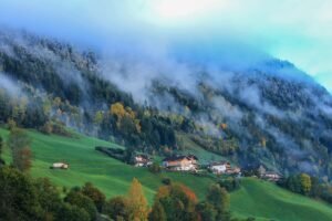
Cradle Mountain, Cradle Mountain TAS 7306, Australia
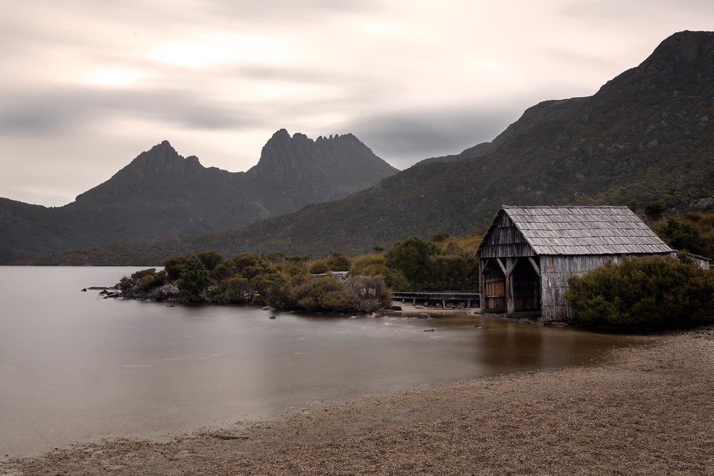
Location: Cradle Mountain TAS 7306, Australia
Cradle Mountain National Park is part of a UNESCO World Heritage Area, covering one-quarter of Tasmania. The protected flora and fauna of Cradle Mountain give visitors the opportunity to see many animal species up close.
Like the wallaby, the wombat is a herbivorous marsupial that is often seen in Tasmania. [Music] Despite its friendly appearance, one shouldn’t forget the power of its jaws, capable of tackling the bark and roots of trees that it feeds on. This animal, strong enough to knock over a man, is, however, the prey of a smaller carnivorous marsupial—the Tasmanian devil.
As it is essentially nocturnal, the Tasmanian devil is difficult to spot in the wild.
“But a lot of people have this idea that devils are a terribly aggressive, ferocious species. In fact, they’re not—they’re quite shy and very wary of human beings. It’s just that they communicate by vocalizing a lot, and it’s very noisy. Human beings often equate that with aggressive behavior, but it’s just communication for these guys.”
The Tasmanian devil is threatened with extinction due to a devastating disease: Tasmanian Devil Facial Tumor Disease. This disease prevents them from feeding normally, and animals afflicted with it die of malnutrition.
Nearly 60 percent of wild devils have disappeared over the span of just 12 years.
Lord Howe Island, New South Wales, Australia
Location: New South Wales, Australia
Lord Howe Island is a UNESCO World Heritage-listed island, located about 600 km off the coast of Eastern Australia. It is a place of unique beauty, with volcanic mountains and rainforests lying between surf and lagoon beaches. Lord Howe has the world’s most southerly coral reef, boasting an amazing diversity of marine life, including several species found only in the island’s waters.
The island was discovered in May 1788 by the HMS Supply, on a voyage from the newly settled Sydney town. There is no evidence of any human habitation on the island prior to this. It soon became a supply point on trips to Norfolk Island, as well as a base for whaling. The lagoon of the island was used until 1974 as a stopover point for flying boats traveling to America and New Zealand, and also to bring visitors to the island.
Lord Howe Island is crescent-shaped, 10 km long, and 1.5 km wide at its greatest width. The island forms the top of an extinct underwater volcano and seamount, projecting above the surface of the ocean. The eastern-facing crescent of the island, together with a reef, forms a lagoon on the eastern side of the island.
The water here is generally calm. On the western side of the island, there are several sandy surf beaches. The population of Lord Howe Island is approximately 350 people. Only 400 tourists are permitted to visit the island at any one time. Unlike at an island resort, the people who provide services to you are likely to be residents of the island.
Some families have lived there for generations. The people have a genuine affection for the island and possess extensive knowledge of the best spots to snorkel, walk, and picnic. The non-existent mobile phone network is substituted by a “people network,” with messages passing between locals and tourists when they encounter each other around the island.
If you are seeking genuine warmth rather than superficial niceties, the people of Lord Howe won’t disappoint. Lord Howe Island is approximately 2 hours of direct flying time with QantasLink from Sydney, Brisbane, and Port Macquarie. Connecting services are available with Qantas. This flight is one of the most expensive domestic flights in Australia, at around $500 each way, and services are operated by Dash 8 turboprops.
So, this concludes our list, but Australia has plenty more to offer. Let us protect and conserve our nature and its beautiful, wonderful creations.
Thank you for reading my blog! If I’ve missed any natural wonders of Australia, please leave a comment below.
You can find me on Instagram: @dreamytravelersofficial/.